
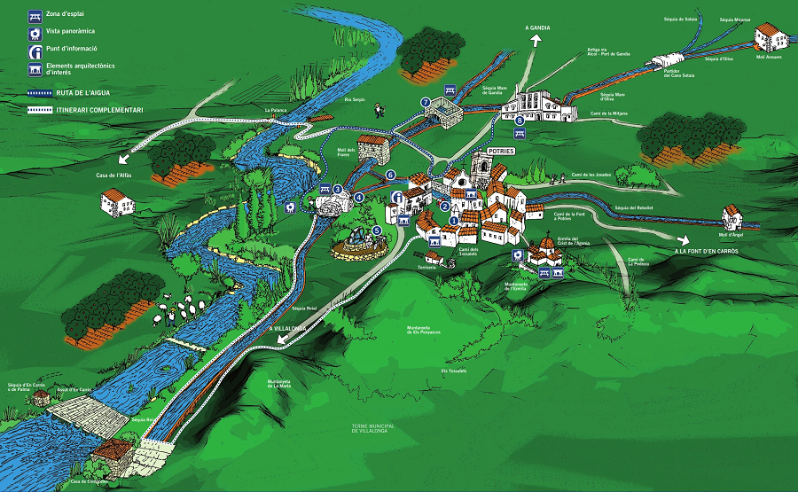
Water Route as it passes through Potries
We offer you an attractive route following country tracks and trails that will bring you into contact with a rural environment that is in danger of disappearing, enabling you to visit an ancient landscape shaped by the efforts of generation upon generation of people from Valencia, and view a group of structures steeped in history associated with the rational use of water.
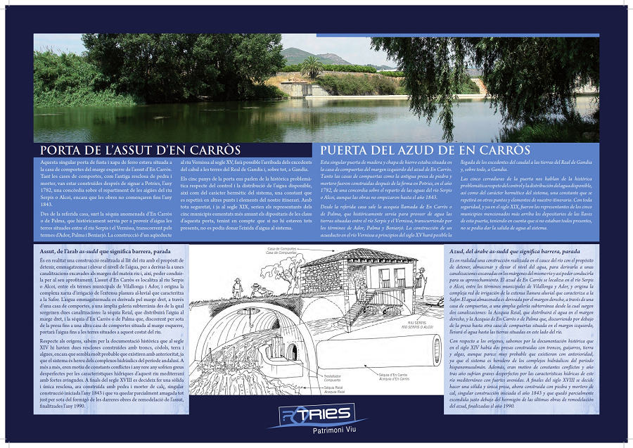
0 TOWN HALL. GATE OF EN CARRÓS DAM
Potries Town Hall is a fantastic example of the stately architecture of the seventeenth century prevalent in country areas of Spain. This mansion was built shortly before 1611 and belonged to a nobleman called Pedro de Borja y Centelles, the second son of the Duke and Duchess of Gandia. In the entrance an extraordinary door with five locks has been maintained, allowing us to begin our journey by talking about the water catchment system, namely the En Carròs dam. This is a structure that was erected on the river bed to hold and store the water and raise its level so that it could be diverted to channels cut into the river banks, making it possible to harvest it for use.
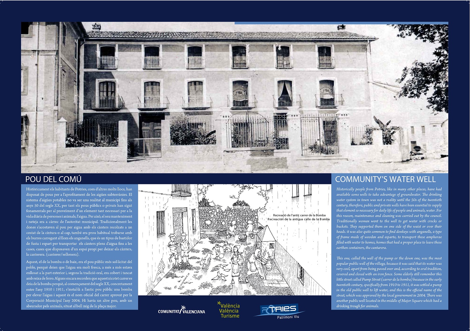
1 EL COMÚN WELL
This was the public well that was most popular with the local residents as its water was said to be really cool, apart from being paved on the outside and, according to legend, covered and closed with iron bars. Some people still remember that this little street was known as la Bomba (the pump) because in the early twentieth century, more exactly, between the years 1910 and 1911, a pump was installed in the old public well to raise the water, with this being the official street name approved by the Local Council in 2004. There was another well, with a trough for animals, located in the middle of the main square.
2 PUBLIC WASHING PLACE
Public washing places appeared in the latter half of the nineteenth century. In the case of Potries, we can also find a considerable number of private washing areas in the houses located beside the Rebollet acequia, or canal, as it passes through the town. This is an architectural and ethnological feature of our urban landscape that is a defining characteristic of water use in recent centuries. Until the nineteen sixties, in Potries there were four public washing places, of which two still remain today. These all used the water flowing in the Rebollet acequia, by placing some stone slabs there to wash the clothes and dishes, leaning inwards along the top of one of the walls of the ditch.

3 CASA FOSCA
The house known as Casa Fosca is a simple construction, located in an area of farmland, and covered with an impressive barrel vault made of stonework and lime mortar that was erected over the canal known as the Acequia Real. The architectural simplicity and economy of resources are in stark contrast with the relevance and significance of this early headgate for the entire water system. Its function was to divide the waters of the Acequia Real coming from the dam into two main channels, the Rebollet and the Común serving Gandía and Oliva. Although the architecture is simple, it has a solid, completely sealed structure, acting as a kind of deterrent to stop anyone from changing the correct distribution of the water. The only person authorised to enter is the irrigation ditch keeper, who is in charge and responsible for keeping the system in good working order.

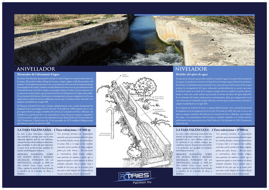
4 WATER LEVELLER
This is an element that enables the flow of water to be calculated at a specific point in the irrigation ditch. They can be seen throughout the whole network, always downstream from the system’s headgates. Bulging against the inner side of the walls of the canal can strangle the water flow, greatly reducing its section, which together with unevenness in the bed of the ditch increases the flow rate at the top. Hence there is a water level gauge at this point to verify the amount of water available. This component is one of the system’s more contemporary features, given that the unit of measurement originally used was the Valencian yard, with the metric system being adopted all over the world in the nineteenth century.
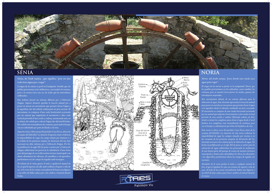
5 WATERWHEEL
The waterwheel is located near the Casa Fosca headgate at a higher level in the Rebollet acequia. The wheel’s location shows that it was impossible to irrigate the fields located upstream or in the vicinity of the initial diversion canals along the river, making it necessary to incorporate another system to collect water. In fact, the proliferation of motor-driven wells in the twentieth century to extract groundwater led to the modification of a large part of the dry farmland in our municipalities: where olive, almond or carob trees once abounded there are now irrigated lands planted with orange groves. This element uses animal traction to power a mechanism that enables groundwater to be lifted to the surface by means of a dug well.
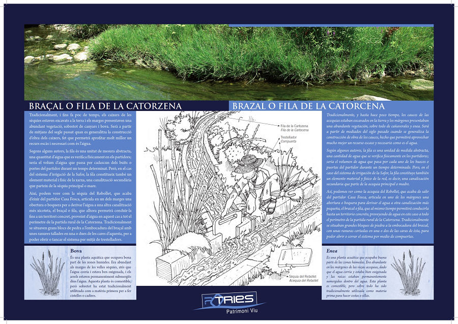
6 LA CATORZENA BRANCH OR FLUME
Some writers say that the fila is a discharge, an abstract measurement referring to a quantity of water that is verified physically in the headgates. That is to say, it is the volume of water that passes through each of the holes or gates during a certain period of time. However, in the case of the irrigation system in La Safor, the fila is also a physical, material component of the network, i.e. a secondary channel or flume that branches off the main channel. Thus we can see how, after leaving the Casa Fosca headgate, the Rebollet acequia carves out an opening or entrance in one of the banks to divert the water to another smaller channel – known as a branch or flume – which, at the same time, will also allow it to be taken to a specific area, supplying water in this case to the whole perimeter of the Catorzena countryside.
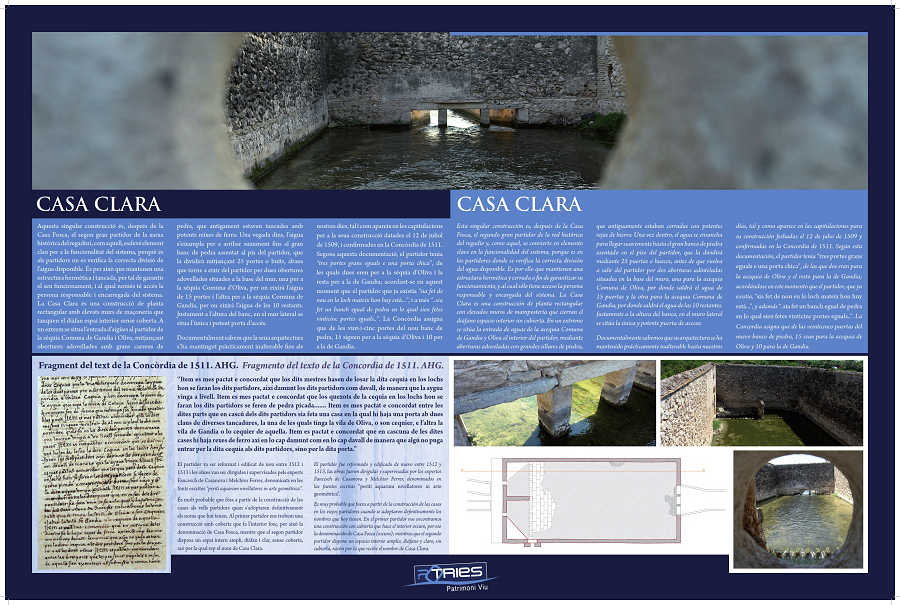
7 CASA CLARA
This unique construction handles the second largest diversion of the historic irrigation system, after the Casa Fosca and, as in the case of the former, is also a key element in making the system work since it is here in the headgates that the correct division of the amount of water available is verified. For this reason the structure is kept sealed and closed so as to ensure that it works properly, with the person in charge and responsible for the system being the only one granted access. Casa Clara is a rectangular building with high stone walls closing off an open inner space without a roof over it. The water from the Gandía and Oliva Común acequia enters at one end of the headgate. At the other end, the water exiting is now verified in two acequias: the Común de Gandíaand the Común de Oliva.
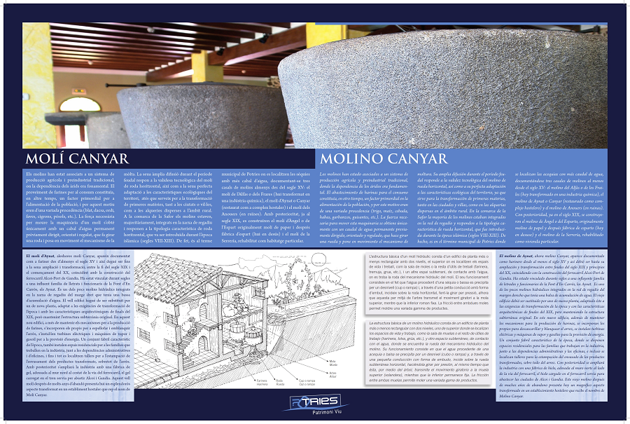
8- MOLÍ CANYAR
Documentary evidence for the Aynat mill dates back to at least the fifteenth century. It has been linked for centuries to the influential Aynat family from Font d’En Carròs, whose members include lawyers, soldiers and civil servants. The old building had to be replaced in the late nineteenth century by a newly-designed construction in line with changing demands prevalent in those days while retaining the original foundations underground. It is one of the few watermills that has been integrated in the irrigation system on the right bank, which had a water reservoir. Apart from the mechanisms for producing flour, this new building also housed the devices for husking and whitening the rice. Electric turbines and steam and diesel engines were also incorporated to generate energy. The industry would subsequently be expanded to include an ice-making plant built on to the northern wall beside the railway track, which met the needs for the supply of ice by rail, both for Alcoy and Gandia. Nowadays this old mill is very impressive, having been turned into a hotel, under the name of Molino Canyar, inside the headgate itself.
 |
 |
 |